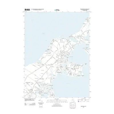
2013 Map of Southold
USGS Topo · Published 2013About this map
Cutchogue and the surrounding North Fork hamlets define this landscape of vineyards and coastal inlets. The map illustrates a dense agricultural and maritime heritage, where historic sites like the Old Burying Ground and Cutchogue Cem sit near active agricultural operations including Wickhams Fruit Farms and Pindar Vineyards. The shoreline is deeply articulated by geographic features such as Horton Point on the Long Island Sound and the sheltered waters of Little Peconic Bay to the south.
Find a feature on this map
223 named features on this map. Tap any name to fly to it.
Don’t see what you’re looking for? This feature index may not catch every label — zoom into the map to look around manually.
Map Details
Editions of this 2013 Southold Map
This is the sole edition of this map. No revisions or reprints were ever made.
Other maps of this area

1903 · Sag Harbor
USGS Topo · 1:62,500

1903 · Riverhead
USGS Topo · 1:62,500

1904 · Sag Harbor
USGS Topo · 1:62,500

1904 · Shelter Island
USGS Topo · 1:62,500

1904 · Riverhead
USGS Topo · 1:62,500

1943 · Riverhead
USGS Topo · 1:62,500

1946 · Sag Harbor
USGS Topo · 1:24,000
1947 · Orient
USGS Topo · 1:24,000

1947 · Mattituck
USGS Topo · 1:24,000

1947 · Mattituck Hills
USGS Topo · 1:24,000