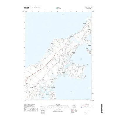
2019 Map of Southold
USGS Topo · Published 2019About this map
Southold and its neighboring North Fork hamlets occupy this maritime landscape where the land is deeply etched by tidal creeks and sheltered bays. The settlement pattern reflects a long history of maritime and agricultural life, from the established village centers of Peconic and Cutchogue to the more recent residential developments at Reydon Shores and Beixedon Estates. Along the northern shore, Horton Point and Horton Neck overlook the Long Island Sound, while to the south, the irregular coastline forms numerous protected harbors like Broadwater Cove and Hog Neck Bay.
Find a feature on this map
190 named features on this map. Tap any name to fly to it.
Don’t see what you’re looking for? This feature index may not catch every label — zoom into the map to look around manually.
Map Details
Editions of this 2019 Southold Map
This is the sole edition of this map. No revisions or reprints were ever made.
Other maps of this area

1903 · Sag Harbor
USGS Topo · 1:62,500

1903 · Riverhead
USGS Topo · 1:62,500

1904 · Sag Harbor
USGS Topo · 1:62,500

1904 · Shelter Island
USGS Topo · 1:62,500

1904 · Riverhead
USGS Topo · 1:62,500

1943 · Riverhead
USGS Topo · 1:62,500

1946 · Sag Harbor
USGS Topo · 1:24,000
1947 · Orient
USGS Topo · 1:24,000

1947 · Mattituck
USGS Topo · 1:24,000

1947 · Mattituck Hills
USGS Topo · 1:24,000