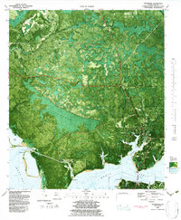
1982 Map of Southport
USGS Topo · Published 1984About this map
Southport and the surrounding coastal wetlands of Bay County are depicted here in a specialized orthophotomap format that blends aerial imagery with topographic data. The landscape is defined by the complex interface of West Bay and North Bay, where numerous tidal inlets like Newman Bayou and Fannin Bayou carve into the shoreline. Industrial and infrastructure footprints are evident near the water, including a powerplant, oil tanks, and a Shrimp Farm west of Warren Bayou. This 1980s-era study provides a clear view of the transitions between developed areas and the dense vegetation of Jacksons Titi. The transportation network is anchored by the Bailey Bridge and Edwards Street, connecting the coastal settlement to the interior woods and features like the Lookout Tower near Vicksburg.
Find a feature on this map
37 named features on this map. Tap any name to fly to it.
Don’t see what you’re looking for? This feature index may not catch every label — zoom into the map to look around manually.
Map Details
Editions of this 1982 Southport Map
Other maps of this area

1943 · Panama City
USGS Topo · 1:31,680

1943 · Panama City Beach
USGS Topo · 1:31,680

1943 · West Bay
USGS Topo · 1:24,000

1943 · Southport
USGS Topo · 1:24,000

1944 · Southport
USGS Topo · 1:24,000

1944 · West Bay
USGS Topo · 1:31,680

1944 · Crystal Lake
USGS Topo · 1:24,000

1944 · Bayhead
USGS Topo · 1:24,000

1944 · Bennett
USGS Topo · 1:24,000

1945 · Bennett
USGS Topo · 1:31,680