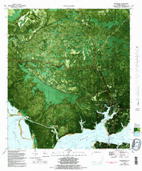
1982 Map of Southport
USGS Topo · Published 1992About this map
The intricate shoreline of North Bay and West Bay dominates this coastal survey, where the community of Southport sits at the junction of several inland bayous. The landscape is a complex network of wetlands and tidal inlets, with Newman Bayou, Fannin Bayou, and Alligator Bayou carving deep into the pine-covered lowlands. Further north, the terrain transitions into the dense marsh of Jacksons Titi and the winding course of Burnt Mill Creek, where the small settlement of Vicksburg is located.
Find a feature on this map
35 named features on this map. Tap any name to fly to it.
Don’t see what you’re looking for? This feature index may not catch every label — zoom into the map to look around manually.
Map Details
Editions of this 1982 Southport Map
Other maps of this area

1943 · Panama City
USGS Topo · 1:31,680

1943 · Panama City Beach
USGS Topo · 1:31,680

1943 · West Bay
USGS Topo · 1:24,000

1943 · Southport
USGS Topo · 1:24,000

1944 · Southport
USGS Topo · 1:24,000

1944 · West Bay
USGS Topo · 1:31,680

1944 · Crystal Lake
USGS Topo · 1:24,000

1944 · Bayhead
USGS Topo · 1:24,000

1944 · Bennett
USGS Topo · 1:24,000

1945 · Bennett
USGS Topo · 1:31,680