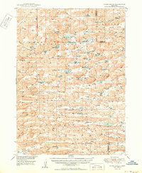
1950 Map of Spade Ranch
USGS Topo · Published 1950This historical map portrays the area of Spade Ranch in 1950, primarily covering Sheridan County as well as portions of Cherry County. Featuring a scale of 1:62500, this map provides a highly detailed snapshot of the terrain, roads, buildings, counties, and historical landmarks in the Spade Ranch region at the time. Published in 1950, it is one of 2 known editions of this map due to revisions or reprints.
Find a feature on this map
51 named features on this map. Tap any name to fly to it.
Don’t see what you’re looking for? This feature index may not catch every label — zoom into the map to look around manually.
Map Details
Editions of this 1950 Spade Ranch Map
2 editions found
Historical Maps of Sheridan County Through Time
91 maps found

1948 Antioch
Sheridan County, NE

1948 Bingham
Sheridan County, NE

1948 Lakeside
Sheridan County, NE

1948 Spade Ranch
Sheridan County, NE

1948 Twin Lakes
Sheridan County, NE

1949 Antioch
Sheridan County, NE

1950 Bingham
Sheridan County, NE

1950 Lakeside
Sheridan County, NE

1950 Skunk Lake
Sheridan County, NE

1950 Spade Ranch
Sheridan County, NE

1950 Twin Lakes
Sheridan County, NE

1960 Hay Springs SE
Sheridan County, NE

1960 Hay Springs SW
Sheridan County, NE

1966 Hay Springs NE
Sheridan County, NE

1966 Rushville SW
Sheridan County, NE

1969 Beaver Wall
Sheridan County, NE

1969 Bovee Valley West
Sheridan County, NE

1969 Clinton NE
Sheridan County, NE

1969 Clinton NW
Sheridan County, NE

1969 Clinton SW
Sheridan County, NE

1969 Gordon NW
Sheridan County, NE

1969 Rushville NE
Sheridan County, NE

1969 Rushville SE
Sheridan County, NE

1969 South Of Gordon
Sheridan County, NE

1969 Whiteclay SE
Sheridan County, NE

1969 Whiteclay
Sheridan County, NE

1969 Whiteclay SW
Sheridan County, NE

1989 Antioch
Sheridan County, NE

1989 Argo Hill
Sheridan County, NE

1989 Arnold Lake
Sheridan County, NE

1989 Billys Lake
Sheridan County, NE

1989 Bingham
Sheridan County, NE

1989 Dolly Warden Lake
Sheridan County, NE

1989 Ellsworth
Sheridan County, NE

1989 Gaunt Lake
Sheridan County, NE

1989 Green Lake
Sheridan County, NE

1989 Jesse Lke
Sheridan County, NE

1989 Krause Lake East
Sheridan County, NE

1989 Krause Lake West
Sheridan County, NE

1989 Lakeside
Sheridan County, NE

1989 Lowe Valley
Sheridan County, NE

1989 Peter Long Lake
Sheridan County, NE

1989 Skunk Lake NE
Sheridan County, NE

1989 Skunk Lake NW
Sheridan County, NE

1989 Skunk Lake
Sheridan County, NE

1989 Skunk Lake SW
Sheridan County, NE

1989 Smith Lake
Sheridan County, NE

1989 Twin Lakes NE
Sheridan County, NE

1989 Twin Lakes
Sheridan County, NE

1989 White Lake
Sheridan County, NE

1989 Wolford Valley
Sheridan County, NE

2021 Antioch
Sheridan County, NE

2021 Argo Hill
Sheridan County, NE

2021 Arnold Lake
Sheridan County, NE

2021 Beaver Wall
Sheridan County, NE

2021 Billys Lake
Sheridan County, NE

2021 Bingham
Sheridan County, NE

2021 Bovee Valley West
Sheridan County, NE

2021 Clinton NE
Sheridan County, NE

2021 Clinton NW
Sheridan County, NE

2021 Clinton SW
Sheridan County, NE

2021 Dolly Warden Lake
Sheridan County, NE

2021 Ellsworth
Sheridan County, NE

2021 Gaunt Lake
Sheridan County, NE

2021 Gordon NW
Sheridan County, NE

2021 Green Lake
Sheridan County, NE

2021 Hay Springs NE
Sheridan County, NE

2021 Hay Springs SE
Sheridan County, NE

2021 Hay Springs SW
Sheridan County, NE

2021 Jesse Lake
Sheridan County, NE

2021 Krause Lake East
Sheridan County, NE

2021 Krause Lake West
Sheridan County, NE

2021 Lakeside
Sheridan County, NE

2021 Lowe Valley
Sheridan County, NE

2021 Peter Long Lake
Sheridan County, NE

2021 Rushville NE
Sheridan County, NE

2021 Rushville SE
Sheridan County, NE

2021 Rushville SW
Sheridan County, NE

2021 Skunk Lake NE
Sheridan County, NE

2021 Skunk Lake NW
Sheridan County, NE

2021 Skunk Lake
Sheridan County, NE

2021 Skunk Lake SW
Sheridan County, NE

2021 Smith Lake
Sheridan County, NE

2021 South of Gordon
Sheridan County, NE

2021 Twin Lakes NE
Sheridan County, NE

2021 Twin Lakes
Sheridan County, NE

2021 Whiteclay SE
Sheridan County, NE

2021 Whiteclay
Sheridan County, NE

2021 Whiteclay SW
Sheridan County, NE

2021 White Lake
Sheridan County, NE

2021 Wolford Valley
Sheridan County, NE