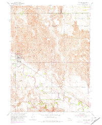
1954 Map of Spalding
USGS Topo · Published 1978About this map
Cedar River dominates this mid-century landscape, winding through a valley defined by the Union Pacific railroad corridor. The village of Spalding serves as the primary hub, showing a concentrated street grid and rail infrastructure typical of Nebraska's agricultural service centers during this era. The surrounding plains are divided into distinct named regions such as Bonanza, Dublin, and Leo Valley, each supported by a network of one-room schoolhouses including School No 47 and School No 22. This 1954 survey, with 1974 photo-revisions, highlights the rural transition from horse-and-wagon spacing to more modern road networks. For genealogists and local historians, the placement of St Michaels Cem and the small settlement of Freeman offers precise locations for family research in Greeley County. The map provides a clear picture of the Missouri River Basin development area, where water features like Mud Creek dictated the placement of schools and homesteads.
Find a feature on this map
23 named features on this map. Tap any name to fly to it.
Don’t see what you’re looking for? This feature index may not catch every label — zoom into the map to look around manually.
Map Details
Editions of this 1954 Spalding Map
3 editions found
Other maps of this area

1954 · Cedar Rapids
USGS Topo · 1:24,000

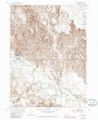
1954 · Spalding
USGS Topo · 1:24,000

1954 · Spalding SW
USGS Topo · 1:24,000

1954 · Akron
USGS Topo · 1:24,000

1954 · Spalding NW
USGS Topo · 1:24,000

1954 · Spalding SE
USGS Topo · 1:24,000

1955 · Broken Bow
USGS Topo · 1:250,000

1956 · Broken Bow
USGS Topo · 1:250,000

1960 · Spalding 2 SW
USGS Topo · 1:24,000

1960 · Spalding 2 SE
USGS Topo · 1:24,000