1959 Map of Spanaway
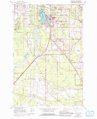
USGS Topo · Published 1991About this map
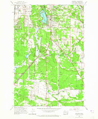
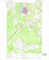
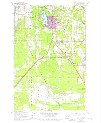
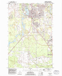
Spanaway Lake sits at the heart of this landscape, its western shores bordering the expansive Mc Chord Air Force Base. The transition from military installation to civilian settlement is marked by the growing residential patterns of Spanaway and the surrounding agricultural tracts. To the south, the Thirteenth Division Prairie remains largely open, reflecting a landscape still defined by its glacial origins and early pioneer claims. Genealogists will find interest in localized burial sites like Jeschke Cemetery and Henry Smith Cemetery, which predate the denser suburban expansion shown in later purple revisions. Educational and social hubs of the late 1950s, such as the Mary Mount Military Academy and Brookdale Golf Club, provide a window into the community's mid-century character before the rapid development of the south Puget Sound corridor.
Find a feature on this map
39 named features on this map. Tap any name to fly to it.
Don’t see what you’re looking for? This feature index may not catch every label — zoom into the map to look around manually.
Map Details
Editions of this 1959 Spanaway Map
5 editions found
Other maps of this area

1897 · Tacoma
USGS Topo · 1:125,000

1900 · Tacoma
USGS Topo · 1:125,000

1916 · Chehalis
USGS Topo · 1:125,000

1937 · Eatonville
USGS Topo · 1:125,000

1940 · Anderson Island
USGS Topo · 1:62,500

1941 · Tanwax Lake
USGS Topo · 1:62,500

1941 · Tacoma South
USGS Topo · 1:62,500

1944 · Tacoma South
USGS Topo · 1:62,500

1944 · Yelm
USGS Topo · 1:62,500

1944 · Ohop Valley
USGS Topo · 1:62,500