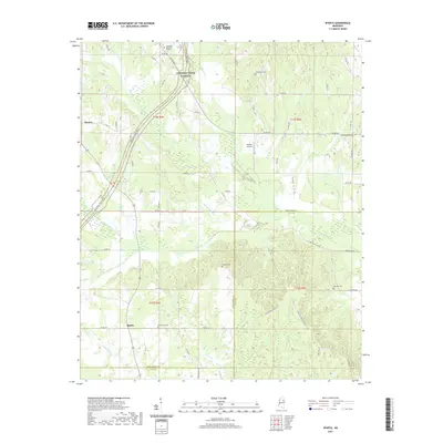
2021 Map of Sparta
USGS Topo · Published 2021About this map
Sparta and Sonora anchor this rural landscape in the northeastern corner of Mississippi, where the border of Chickasaw and Clay Counties cuts through a terrain defined by winding creeks. The modern Natchez Trace Pkwy sweeps across the northwest quadrant, following the historic travel corridor past Chickasaw Memorial Gardens. For those tracing local families, the map identifies several rural burial grounds, including Oak Grove Cem near Sparta and Macedonia Cem to the northeast. The geography is dominated by a complex network of waterways such as Houlka Cr and Horse Nation Cr, which feed into the lowlands. Small-scale aviation is represented by Kimmel Airport, located near the center of the survey area, while the eastern edge is marked by Linn Lake and the New Hope Cem.
Find a feature on this map
66 named features on this map. Tap any name to fly to it.
Don’t see what you’re looking for? This feature index may not catch every label — zoom into the map to look around manually.
Map Details
Editions of this 2021 Sparta Map
This is the sole edition of this map. No revisions or reprints were ever made.
Other maps of this area

1953 · West Point
USGS Topo · 1:250,000

1958 · West Point
USGS Topo · 1:250,000

1959 · Van Vleet
USGS Topo · 1:62,500

1959 · Pheba
USGS Topo · 1:62,500

1963 · West Point
USGS Topo · 1:250,000
1972 · Houston West
USGS Topo · 1:24,000

1972 · Mantee
USGS Topo · 1:24,000
1972 · Woodland
USGS Topo · 1:24,000

1982 · West Point
USGS Topo · 1:100,000

1984 · West Point
USGS Topo · 1:250,000