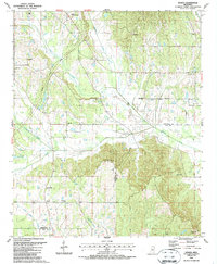
1987 Map of Sparta
USGS Topo · Published 1987About this map
Sparta serves as the focal point for this rural landscape where the border of Chickasaw and Clay Counties meets. The terrain is defined by a dense network of tributaries including Houlka Creek, Chico Creek, and Cane Creek, which carve through the agricultural fields and timberland of the region. A significant historical corridor, the Natchez Trace Parkway, cuts diagonally across the northwestern portion of the map, providing a modern connection to an ancient wilderness thoroughfare.
Find a feature on this map
26 named features on this map. Tap any name to fly to it.
Don’t see what you’re looking for? This feature index may not catch every label — zoom into the map to look around manually.
Map Details
Editions of this 1987 Sparta Map
This is the sole edition of this map. No revisions or reprints were ever made.
Other maps of this area

1953 · West Point
USGS Topo · 1:250,000

1958 · West Point
USGS Topo · 1:250,000

1959 · Van Vleet
USGS Topo · 1:62,500

1959 · Pheba
USGS Topo · 1:62,500

1963 · West Point
USGS Topo · 1:250,000
1972 · Houston West
USGS Topo · 1:24,000

1972 · Mantee
USGS Topo · 1:24,000
1972 · Woodland
USGS Topo · 1:24,000

1982 · West Point
USGS Topo · 1:100,000

1984 · West Point
USGS Topo · 1:250,000