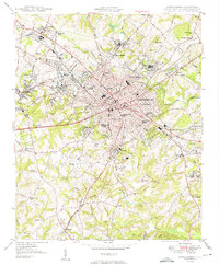
1949 Map of Spartanburg
USGS Topo · Published 1949About this map
Spartanburg serves as the hub of a dense rail and textile network just after the war, defined by the convergence of the Southern, Clinchfield, and Charleston and Western Carolina railroads. The map documents the city's educational and institutional footprint, from the campuses of Wofford College and Converse College to the State Deaf and Blind Sch on the city's eastern edge. Surrounding the urban core, distinct mill villages and residential developments like Saxon, Arkwright, and Whitney reveal the industrial social structure of the era. To the northwest, Hayne Sta and the County Hospital mark the periphery, while rural reaches like Roebuck and Canaan show a landscape still primarily defined by the winding paths of Lawson Creek and Fairforest Creek.
Find a feature on this map
75 named features on this map. Tap any name to fly to it.
Don’t see what you’re looking for? This feature index may not catch every label — zoom into the map to look around manually.
Map Details
Editions of this 1949 Spartanburg Map
3 editions found
Other maps of this area

1907 · Saluda
USGS Topo · 1:125,000

1935 · Greer
USGS Topo · 1:48,000

1938 · Greer
USGS Topo · 1:62,500

1941 · Spartanburg
USGS Topo · 1:250,000

1947 · Spartanburg
USGS Topo · 1:62,500

1949 · Spartanburg
USGS Topo · 1:24,000

1949 · Spartanburg
USGS Topo · 1:62,500

1953 · Spartanburg
USGS Topo · 1:250,000

1953 · Charlotte
USGS Topo · 1:250,000

1954 · Charlotte
USGS Topo · 1:250,000