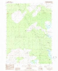
1988 Map of Spaulding Butte
USGS Topo · Published 1988About this map
The Modoc National Forest dominates this high-country landscape in Northeastern California, where the terrain is marked by volcanic features and water management infrastructure of the late 1980s. Notable landmarks like Spaulding Butte and Damons Butte rise above the surrounding plateau, while the subterranean Damons Cave suggests the complex geology of the Modoc region. The presence of a Quarantine Station near the northern boundary reflects the area's role in monitoring movement along the local transportation corridors.
Find a feature on this map
18 named features on this map. Tap any name to fly to it.
Don’t see what you’re looking for? This feature index may not catch every label — zoom into the map to look around manually.
Map Details
Editions of this 1988 Spaulding Butte Map
This is the sole edition of this map. No revisions or reprints were ever made.
Other maps of this area

1886 · Modoc Lava Bed
USGS Topo · 1:250,000

1892 · Modoc Lava-Bed
USGS Topo · 1:250,000

1952 · Timber Mountain
USGS Topo · 1:62,500

1952 · Hackamore
USGS Topo · 1:62,500

1954 · Alturas
USGS Topo · 1:250,000

1958 · Alturas
USGS Topo · 1:250,000

1962 · Alturas
USGS Topo · 1:250,000

1962 · Crank Mountain
USGS Topo · 1:62,500

1962 · White Horse
USGS Topo · 1:62,500

1965 · Alturas
USGS Topo · 1:250,000