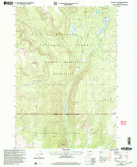
2000 Map of Specimen Creek
USGS Topo · Published 2005About this map
Yellowstone National Park and the Gallatin National Forest converge in this high-altitude landscape revised at the turn of the millennium. The terrain is defined by a dense network of drainage systems and high ridges, including the prominent Hellroaring Mountain and Bull Mountain. Water features such as Specimen Creek, which includes the marked Specimen Falls, and Hellroaring Creek carve through the deep valleys of the Absaroka-Beartooth Wilderness. The presence of the Poacher Trail, Coyote Trail, and Buffalo Trail highlights a landscape managed for conservation and backcountry access rather than permanent settlement. To the southeast, the broad expanse of the Buffalo Plateau overlooks the park boundaries, illustrating the transition from forested peaks to high alpine meadows.
Find a feature on this map
26 named features on this map. Tap any name to fly to it.
Don’t see what you’re looking for? This feature index may not catch every label — zoom into the map to look around manually.
Map Details
Editions of this 2000 Specimen Creek Map
This is the sole edition of this map. No revisions or reprints were ever made.
Other maps of this area

1885 · Gallatin
USGS Topo · 1:125,000

1885 · Gallatin
USGS Topo · 1:125,000

1886 · Canyon
USGS Topo · 1:125,000

1891 · Livingston
USGS Topo · 1:250,000

1893 · Livingston
USGS Topo · 1:250,000

1895 · Canyon
USGS Topo · 1:125,000

1896 · Canyon
USGS Topo · 1:125,000

1901 · Canyon
USGS Topo · 1:125,000

1901 · Gallatin
USGS Topo · 1:125,000

1907 · Canyon
USGS Topo · 1:125,000