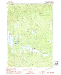
1988 Map of Spectacle Pond
USGS Topo · Published 1988About this map
Brighton State Park and the northeastern shores of Island Pond dominate this landscape in Vermont's Northeast Kingdom, showcasing a region defined by its glacial waters and timbered highlands. The Canadian National railroad follows the low ground along the Nulhegan River, connecting the small settlements of East Brighton and Wenlock. This 1980s survey captures the area’s infrastructure before significant modern changes, including the John N Boyland State Airport and a lakeside Campground.
Find a feature on this map
43 named features on this map. Tap any name to fly to it.
Don’t see what you’re looking for? This feature index may not catch every label — zoom into the map to look around manually.
Map Details
Editions of this 1988 Spectacle Pond Map
2 editions found
Other maps of this area

1920 · Guildhall
USGS Topo · 1:62,500

1924 · Island Pond
USGS Topo · 1:48,000

1926 · Island Pond
USGS Topo · 1:62,500

1929 · Averill
USGS Topo · 1:62,500

1931 · Guildhall
USGS Topo · 1:48,000

1933 · Guildhall
USGS Topo · 1:48,000

1937 · Guildhall
USGS Topo · 1:62,500

1950 · Lewiston
USGS Topo · 1:250,000

1951 · Burke
USGS Topo · 1:62,500

1953 · Island Pond
USGS Topo · 1:62,500