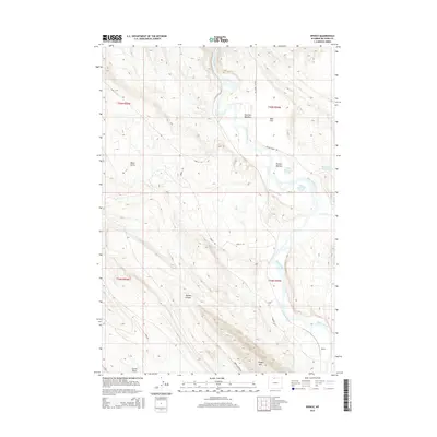
2015 Map of Spence
USGS Topo · Published 2015About this map
Bighorn River currents shape this Big Horn County landscape, where the water's path carves through the transition between high flats and canyon terrain. The small settlement of Spence sits near the southern bend of the river, serving as a localized point of interest in an area defined by its hydrology and livestock-supporting geography. Water management is evident through the presence of the Phelps Reservoir Number 1, Phelps Reservoir Number 2, and Bethurem Reservoir, which collect runoff from the surrounding drainages. Dramatic relief is found at Sheep Mtn and within the walls of Ribbon Canyon, while named areas like Perkins Bottom and Red Rim Meadows indicate specific pockets of more level, usable ground. A network of rural lanes, including Spence Rd and Crystal Creek Rd, provides the primary framework for navigating this high-desert environment.
Find a feature on this map
26 named features on this map. Tap any name to fly to it.
Don’t see what you’re looking for? This feature index may not catch every label — zoom into the map to look around manually.
Map Details
Editions of this 2015 Spence Map
This is the sole edition of this map. No revisions or reprints were ever made.
Other maps of this area

1955 · Cody
USGS Topo · 1:250,000

1958 · Cody
USGS Topo · 1:250,000

1962 · Cody
USGS Topo · 1:250,000

1964 · Kane
USGS Topo · 1:24,000

1964 · Lovell Lakes
USGS Topo · 1:24,000
1966 · Sheep Canyon
USGS Topo · 1:24,000
1966 · Cottonwood Canyon
USGS Topo · 1:24,000

1966 · North Emblem Reservoir
USGS Topo · 1:24,000
1966 · Greybull North
USGS Topo · 1:24,000

1966 · Emblem SE
USGS Topo · 1:24,000