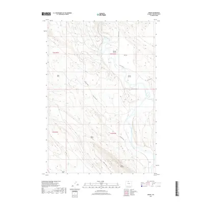
2017 Map of Spence
USGS Topo · Published 2017About this map
The Bighorn River carves through this northern Wyoming landscape, defining a corridor of riparian flats and dramatic elevation changes. The settlement of Spence sits along the river's eastern bank, positioned where the terrain transitions toward the massive bulk of Sheep Mountain. This area is characterized by its resource-driven infrastructure, notably the Spence Oil Field Rd which snakes through the western portion of the quadrangle.
Find a feature on this map
20 named features on this map. Tap any name to fly to it.
Don’t see what you’re looking for? This feature index may not catch every label — zoom into the map to look around manually.
Map Details
Editions of this 2017 Spence Map
This is the sole edition of this map. No revisions or reprints were ever made.
Other maps of this area

1955 · Cody
USGS Topo · 1:250,000

1958 · Cody
USGS Topo · 1:250,000

1962 · Cody
USGS Topo · 1:250,000

1964 · Kane
USGS Topo · 1:24,000

1964 · Lovell Lakes
USGS Topo · 1:24,000
1966 · Sheep Canyon
USGS Topo · 1:24,000
1966 · Cottonwood Canyon
USGS Topo · 1:24,000

1966 · North Emblem Reservoir
USGS Topo · 1:24,000
1966 · Greybull North
USGS Topo · 1:24,000

1966 · Emblem SE
USGS Topo · 1:24,000