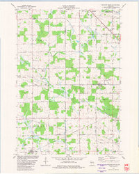
1979 Map of Spencer South
USGS Topo · Published 1980About this map
The Soo Line railroad cuts diagonally across this landscape, connecting the northern settlement of Spencer with the agricultural terrain of Clark and Marathon counties. The map captures a rural environment defined by the winding course of the Yellow River and its South Branch, where the drainage patterns of the Mc Millan Marsh dominate the northeast. This wetland area, designated as the Mc Millan Marsh State Public Hunting Grounds, signifies the region's historical reliance on seasonal land use and wildlife management.
Find a feature on this map
28 named features on this map. Tap any name to fly to it.
Don’t see what you’re looking for? This feature index may not catch every label — zoom into the map to look around manually.
Map Details
Editions of this 1979 Spencer South Map
This is the sole edition of this map. No revisions or reprints were ever made.
Other maps of this area

1902 · Marathon
USGS Topo · 1:125,000

1953 · Abbotsford
USGS Topo · 1:48,000

1953 · Stratford
USGS Topo · 1:48,000

1953 · Eau Claire
USGS Topo · 1:250,000

1954 · Granton
USGS Topo · 1:62,500

1954 · Marshfield
USGS Topo · 1:62,500

1958 · Eau Claire
USGS Topo · 1:250,000

1963 · Stratford
USGS Topo · 1:62,500

1963 · Abbotsford
USGS Topo · 1:62,500

1964 · Eau Claire
USGS Topo · 1:250,000