2022 Map of Sperry
USGS Topo · Published 2022About this map
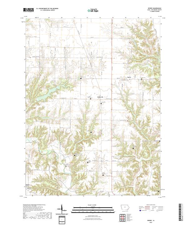
Sperry and Dodgeville anchor this northern Des Moines County landscape, where agriculture and local heritage intersect along the drainages of Flint Creek and Knotty Cr. The area is notably dense with small family and congregational burial grounds, offering a high degree of information gain for those tracing 19th and 20th-century settlement patterns. Notable sites include the Salem Lutheran Cem, Saint Johns Cem, and the unique Walker Farm Plot. The terrain is defined by the branching tributaries of Yellow Spring Cr and Big Hollow Cr, which carve into the upland plains. This survey captures the rural character of the region as it exists in the early 21st century, showing the enduring road network of Iowa City Rd and Pleasant Grove Rd that has connected these farming communities for generations.
Find a feature on this map
78 named features on this map. Tap any name to fly to it.
Don’t see what you’re looking for? This feature index may not catch every label — zoom into the map to look around manually.
Map Details
Editions of this 2022 Sperry Map
This is the sole edition of this map. No revisions or reprints were ever made.
Other maps of this area

1934 · Burlington
USGS Topo · 1:48,000

1940 · Burlington
USGS Topo · 1:62,500

1946 · Wapello
USGS Topo · 1:62,500

1949 · Wapello
USGS Topo · 1:62,500

1958 · Burlington
USGS Topo · 1:250,000

1958 · Davenport
USGS Topo · 1:250,000

1961 · Burlington
USGS Topo · 1:250,000

1961 · Davenport
USGS Topo · 1:250,000

1962 · Davenport
USGS Topo · 1:250,000

1963 · Burlington
USGS Topo · 1:250,000