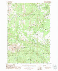
1988 Map of Sphinx Mountain
USGS Topo · Published 1989About this map
Sphinx Mountain and the distinctive formation known as The Helmet dominate this high-altitude landscape within the Lee Metcalf Wilderness. This 1988 provisional survey documents a transition zone between the Gallatin National Forest and the Beaverhead National Forest, characterized by steep drainage networks like McAtee Basin and Yellow Mule Creek. The presence of the Yellow Mule Ranger Cabin and the Manley Camp settlement reflect the area's history of forest management and early backcountry habitation. A complex system of named pack trails connects remote landmarks, including the Indian Crossing on Indian Creek. The mapping of the Bear Creek Wildlife Mgmt Area alongside these wilderness boundaries illustrates the era's focus on conservation and public land division in Madison County.
Find a feature on this map
33 named features on this map. Tap any name to fly to it.
Don’t see what you’re looking for? This feature index may not catch every label — zoom into the map to look around manually.
Map Details
Editions of this 1988 Sphinx Mountain Map
2 editions found
Other maps of this area

1888 · Three Forks
USGS Topo · 1:250,000

1894 · Three Forks
USGS Topo · 1:250,000

1895 · Three Forks
USGS Topo · 1:250,000

1947 · Bozeman
USGS Topo · 1:250,000

1948 · Bozeman
USGS Topo · 1:250,000

1949 · Ennis
USGS Topo · 1:62,500

1950 · Cameron
USGS Topo · 1:62,500

1950 · Spanish Peaks
USGS Topo · 1:62,500

1950 · Sphinx Mountain
USGS Topo · 1:62,500

1955 · Bozeman
USGS Topo · 1:250,000