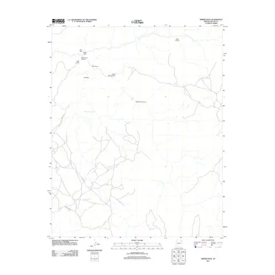
2011 Map of Spider Rock
USGS Topo · Published 2011About this map
Spider Rock rises from the floor of Monument Canyon, serving as a central geological landmark in this high-desert landscape of Arizona. The 2011 survey reveals a complex network of sheer-walled drainages, including Bat Canyon, Mule Canyon, and Horse Track Canyon. Access through the area is defined by specialized routes such as Indian Rte 7 and the Bat Canyon Spur, providing connections between the canyon rims and the vast interior plateaus. Water sources are critical but sparse, marked on the map by isolated points like Elephant Grass Spring, Glofer Spring, and Oak Spring. Human presence is highlighted at the Spider Rock Overlook, where the convergence of Face Rock and other spire-like formations creates a distinct topographic profile. The map reflects a landscape where travel is strictly governed by the deep incisions of Small Twin Canyon and the massive monolith of Bat Rock.
Find a feature on this map
16 named features on this map. Tap any name to fly to it.
Don’t see what you’re looking for? This feature index may not catch every label — zoom into the map to look around manually.
Map Details
Editions of this 2011 Spider Rock Map
This is the sole edition of this map. No revisions or reprints were ever made.
Other maps of this area

1886 · Fort Defiance
USGS Topo · 1:250,000

1892 · Fort Defiance
USGS Topo · 1:250,000

1892 · Canyon De Chelly
USGS Topo · 1:250,000

1954 · Shiprock
USGS Topo · 1:250,000

1954 · Gallup
USGS Topo · 1:250,000

1955 · Zith-Tusayan Butte 2 NW
USGS Topo · 1:24,000

1955 · Zith-Tusayan Butte 2 NE
USGS Topo · 1:24,000

1955 · Sonsala Butte 4 NW
USGS Topo · 1:24,000

1955 · Sonsala Butte 3 SE
USGS Topo · 1:24,000
1955 · Zith-Tusayan Butte 1 NW
USGS Topo · 1:24,000