
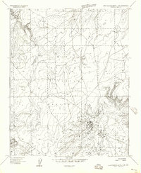
1955 Map of Zith-Tusayan Butte 2 NE
USGS Topo · Published 1957About this map
The Defiance Plateau dominates this mid-century topographic study, showing a deeply incised landscape within the Indian Reservation. The map captures the northeastern corner of the Canyon De Chelly National Monument, where the boundary cuts across high mesas and steep drainage systems. Water sources are critical markers in this arid environment, with labels identifying specific locations like Segetoa Spring and the prominent Fluted Rock. The drainage pattern is defined by the winding course of Nazlini Wash and Lone Tule Wash, which have carved intricate contours into the plateau. This preliminary edition provides a precise look at the unimproved roads and high-elevation points such as Summit before later developments in the region.
Find a feature on this map
10 named features on this map. Tap any name to fly to it.
Don’t see what you’re looking for? This feature index may not catch every label — zoom into the map to look around manually.
Map Details
Editions of this 1955 Zith-Tusayan Butte 2 NE Map
This is the sole edition of this map. No revisions or reprints were ever made.
Other maps of this area

1886 · Fort Defiance
USGS Topo · 1:250,000

1892 · Fort Defiance
USGS Topo · 1:250,000

1892 · Canyon De Chelly
USGS Topo · 1:250,000

1954 · Shiprock
USGS Topo · 1:250,000

1954 · Gallup
USGS Topo · 1:250,000

1955 · Zith-Tusayan Butte 2 SE
USGS Topo · 1:24,000

1955 · Zith-Tusayan Butte 2 SW
USGS Topo · 1:24,000

1955 · Zith-Tusayan Butte 2 NW
USGS Topo · 1:24,000

1955 · Sonsala Butte 3 SE
USGS Topo · 1:24,000
1955 · Zith-Tusayan Butte 1 NW
USGS Topo · 1:24,000