
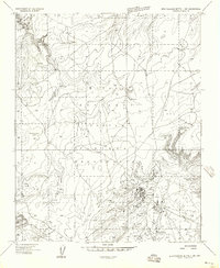
1955 Map of Zith-Tusayan Butte 2 SE
USGS Topo · Published 1957About this map
The Defiance Plateau dominates this mid-century survey of the Navajo Indian Reservation in Apache County. This land is characterized by a high-altitude drainage network where seasonal waters carve through the landscape, creating distinct features such as Ruin Wash, Lone Tule Wash, and Sage House Wash. In the southern portion of the quadrangle, Black Creek and Kin-li-chee Creek converge, providing a more permanent water source in an otherwise arid region. The presence of a Well and a Spring along these drainage lines highlights the vital importance of groundwater for survival on the reservation.
Find a feature on this map
15 named features on this map. Tap any name to fly to it.
Don’t see what you’re looking for? This feature index may not catch every label — zoom into the map to look around manually.
Map Details
Editions of this 1955 Zith-Tusayan Butte 2 SE Map
This is the sole edition of this map. No revisions or reprints were ever made.
Other maps of this area

1886 · Fort Defiance
USGS Topo · 1:250,000

1892 · Fort Defiance
USGS Topo · 1:250,000

1954 · Gallup
USGS Topo · 1:250,000

1955 · Zith-Tusayan Butte 3 NW
USGS Topo · 1:24,000

1955 · Zith-Tusayan Butte 4 NW
USGS Topo · 1:24,000

1955 · Zith-Tusayan Butte 2 SW
USGS Topo · 1:24,000

1955 · Zith-Tusayan Butte 3 NE
USGS Topo · 1:24,000

1955 · Zith-Tusayan Butte 2 NW
USGS Topo · 1:24,000

1955 · Zith-Tusayan Butte 2 NE
USGS Topo · 1:24,000
1955 · Zith-Tusayan Butte 1 NW
USGS Topo · 1:24,000