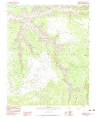
1983 Map of Spider Rock
USGS Topo · Published 1983About this map
Canyon De Chelly carves a deep path through the Navajo Indian Reservation in this 1983 survey, revealing a landscape defined by archaeological significance and geological markers. The terrain is dominated by high plateaus like Middle Mesa and the sheer verticality of the canyon system, featuring world-renowned landmarks such as the Spider Rock spire and the nearby Spider Rock Overlook. This document serves as a detailed record of cultural sites within the Canyon De Chelly National Monument, pinpointing the locations of ancient dwellings including Two Hole Ruin and Cave Ruin. Beyond these structures, the presence of Petroglyphs and named water sources like Elephant Grass Spring and the Hot Rock Windmill illustrate the intersection of historical Navajo land use and the region's preservation as a national monument.
Find a feature on this map
23 named features on this map. Tap any name to fly to it.
Don’t see what you’re looking for? This feature index may not catch every label — zoom into the map to look around manually.
Map Details
Editions of this 1983 Spider Rock Map
This is the sole edition of this map. No revisions or reprints were ever made.
Other maps of this area

1886 · Fort Defiance
USGS Topo · 1:250,000

1892 · Fort Defiance
USGS Topo · 1:250,000

1892 · Canyon De Chelly
USGS Topo · 1:250,000

1954 · Shiprock
USGS Topo · 1:250,000

1954 · Gallup
USGS Topo · 1:250,000

1955 · Zith-Tusayan Butte 2 NW
USGS Topo · 1:24,000

1955 · Zith-Tusayan Butte 2 NE
USGS Topo · 1:24,000

1955 · Sonsala Butte 4 NW
USGS Topo · 1:24,000

1955 · Sonsala Butte 3 SE
USGS Topo · 1:24,000
1955 · Zith-Tusayan Butte 1 NW
USGS Topo · 1:24,000