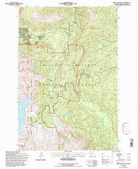
1994 Map of Spirit Lake East
USGS Topo · Published 1996About this map
The Mount St Helens National Volcanic Monument dominates this landscape, showing a recovery in progress following the 1980 eruption. Several interpretive locations, including the Miners Car Interpretive Site and Meta Lake Interpretive Site, document the immediate and long-term effects of the volcanic event on the surrounding Gifford Pinchot National Forest. This survey captures the terrain's state in the mid-1990s, where viewpoints like Harmony Viewpoint and Donnybrook Viewpoint overlook the changed waters of Spirit Lake. The map details a network of mountain trails and forest roads reaching high points such as Goat Mountain and Bismarck Mountain. Notable water features like Harmony Falls and Ryan Lake are situated among the ridges, providing a clear record of the area's hydrology before further natural successions occurred.
Find a feature on this map
49 named features on this map. Tap any name to fly to it.
Don’t see what you’re looking for? This feature index may not catch every label — zoom into the map to look around manually.
Map Details
Editions of this 1994 Spirit Lake East Map
This is the sole edition of this map. No revisions or reprints were ever made.
Other maps of this area

1919 · Mount St Helens
USGS Topo · 1:125,000

1926 · Steamboat Mtn
USGS Topo · 1:125,000

1931 · Steamboat Mtn
USGS Topo · 1:125,000

1950 · Yakima
USGS Topo · 1:250,000

1953 · Hoquiam
USGS Topo · 1:250,000

1957 · Hoquiam
USGS Topo · 1:250,000

1957 · Spirit Lake
USGS Topo · 1:62,500

1958 · Mt St. Helens
USGS Topo · 1:62,500

1958 · Yakima
USGS Topo · 1:250,000

1958 · Hoquiam
USGS Topo · 1:250,000