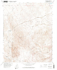
1959 Map of Spirit Mtn
USGS Topo · Published 1976About this map
Goldenrod Mine and Empire Mine are among the scattered workings that define this landscape in the late 1950s. The terrain is dominated by the Newberry Mountains, with the high point of Spirit Mountain overlooking a network of dry washes and canyons. Small settlements and outposts like Camp Thurman and Sacatone provided focal points for human activity amidst the mining operations.
Find a feature on this map
35 named features on this map. Tap any name to fly to it.
Don’t see what you’re looking for? This feature index may not catch every label — zoom into the map to look around manually.
Map Details
Editions of this 1959 Spirit Mtn Map
4 editions found
Other maps of this area

1886 · Camp Mohave
USGS Topo · 1:250,000

1892 · Camp Mohave
USGS Topo · 1:250,000

1926 · Mohave City
USGS Topo · 1:96,000

1942 · Camp Mohave
USGS Topo · 1:250,000

1947 · Kingman
USGS Topo · 1:250,000

1948 · Kingman
USGS Topo · 1:250,000

1950 · Davis Dam
USGS Topo · 1:62,500

1952 · Davis Dam
USGS Topo · 1:62,500

1954 · Kingman
USGS Topo · 1:250,000

1955 · Kingman
USGS Topo · 1:250,000