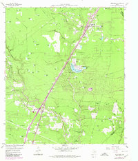
1959 Map of Splendora
USGS Topo · Published 1980About this map
Caney Creek and Peach Creek define the low-lying landscape of Montgomery County in this mid-century survey, which documents a region transitioning through the growth of the Splendora Oil Field. The Southern Pacific railroad serves as the primary spine for development, linking established communities like Splendora and New Caney. While industrial activity is evident in the numerous sludge pits and active pipelines, the map also reveals a dense network of family-named landmarks and rural infrastructure, including the Robinson Cem and Carver Sch. Suburban expansion is signaled by the inclusion of planned residential enclaves such as Roman Forest and Patton Village. Near the Harris County line, the Houston and Harris County Camp for the Girl Scouts and the Union Encampment highlight the area's use for recreation and organized gatherings amidst the dense creek drainages and timbered tracts.
Find a feature on this map
69 named features on this map. Tap any name to fly to it.
Don’t see what you’re looking for? This feature index may not catch every label — zoom into the map to look around manually.
Map Details
Editions of this 1959 Splendora Map
4 editions found
Other maps of this area

1916 · Moonshine Hill
USGS Topo · 1:24,000

1916 · Huffman
USGS Topo · 1:24,000

1919 · Weeden
USGS Topo · 1:31,680

1920 · Moonshine Hill
USGS Topo · 1:31,680

1920 · Huffman
USGS Topo · 1:31,680

1954 · Beaumont
USGS Topo · 1:250,000

1957 · Beaumont
USGS Topo · 1:250,000

1958 · Fostoria
USGS Topo · 1:24,000

1958 · Cleveland
USGS Topo · 1:24,000

1959 · Plum Grove
USGS Topo · 1:24,000