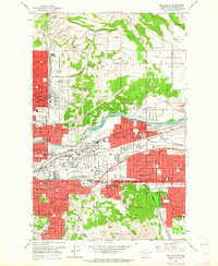
1963 Map of Spokane NE
USGS Topo · Published 1964About this map
Spokane River frontage and a dense network of transcontinental railroads define this 1963 survey of the city's northeast expansion. The landscape transitions from the industrial yards of the Great Northern and Union Pacific railroads near Parkwater and Yardley to the high, open grounds of Orchard Prairie and Pleasant Prairie. Central to the river's bend is Felts Field, then operating as the Spokane Municipal Airport, while the nearby Interstate Fairgrounds stands as a major regional landmark.
Find a feature on this map
113 named features on this map. Tap any name to fly to it.
Don’t see what you’re looking for? This feature index may not catch every label — zoom into the map to look around manually.
Map Details
Editions of this 1963 Spokane NE Map
This is the sole edition of this map. No revisions or reprints were ever made.
Other maps of this area

1901 · Spokane
USGS Topo · 1:125,000

1943 · Mt Spokane
USGS Topo · 1:62,500

1949 · Deer Park
USGS Topo · 1:62,500

1949 · Greenacres
USGS Topo · 1:62,500

1950 · Spokane NE
USGS Topo · 1:24,000

1950 · Spokane SE
USGS Topo · 1:24,000

1950 · Mt Spokane
USGS Topo · 1:62,500

1950 · Spokane SW
USGS Topo · 1:24,000

1950 · Spokane NW
USGS Topo · 1:24,000

1950 · Spokane
USGS Topo · 1:62,500