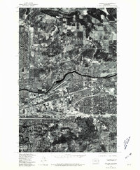
1978 Map of Spokane NE
USGS Topo · Published 1981About this map
The Spokane metropolitan area is captured here in an orthophotograph format, reflecting a period of significant urban and suburban expansion in eastern Washington. The dense street grids of the city transition into the developing neighborhoods of Dishman and the more open terrain surrounding Glenrose. This aerial perspective provides a unique view of the landscape where human development meets the natural geography of the region, notably the winding path of the Spokane River as it cuts through the center of the sheet. To the north, the elevation rises toward Little Baldy, where the suburban sprawl gives way to forested and agricultural land. The map serves as a precise record of the road networks, industrial corridors, and residential patterns of the late 1970s, as documented by the U.S. Geological Survey and the State of Washington Department of Natural Resources.
Find a feature on this map
5 named features on this map. Tap any name to fly to it.
Don’t see what you’re looking for? This feature index may not catch every label — zoom into the map to look around manually.
Map Details
Editions of this 1978 Spokane NE Map
This is the sole edition of this map. No revisions or reprints were ever made.
Other maps of this area

1901 · Spokane
USGS Topo · 1:125,000

1943 · Mt Spokane
USGS Topo · 1:62,500

1949 · Deer Park
USGS Topo · 1:62,500

1949 · Greenacres
USGS Topo · 1:62,500

1950 · Spokane NE
USGS Topo · 1:24,000

1950 · Spokane SE
USGS Topo · 1:24,000

1950 · Mt Spokane
USGS Topo · 1:62,500

1950 · Spokane SW
USGS Topo · 1:24,000

1950 · Spokane NW
USGS Topo · 1:24,000

1950 · Spokane
USGS Topo · 1:62,500