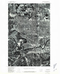
1978 Map of Spokane NW
USGS Topo · Published 1981About this map
The Spokane River carves a deep, winding path through the basaltic landscape of the Inland Northwest in this 1978 orthophotoquad. This aerial perspective, produced in cooperation with the Washington Department of Natural Resources, reveals the dense residential and commercial expansion of Spokane as it pushes northward toward the distinct elevated plateau of Fivemile Prairie. The stark black-and-white imagery captures the city's grid-based development patterns directly adjacent to the dramatic, undeveloped river bluffs, illustrating the tension between urban growth and the region's sharp topographic boundaries. Researchers can observe the mid-century infrastructure and land use of the northwest quadrant before later decades of suburban infill, providing a precise visual record of the city's northern limits at the end of the 1970s.
Find a feature on this map
3 named features on this map. Tap any name to fly to it.
Don’t see what you’re looking for? This feature index may not catch every label — zoom into the map to look around manually.
Map Details
Editions of this 1978 Spokane NW Map
This is the sole edition of this map. No revisions or reprints were ever made.
Other maps of this area

1901 · Spokane
USGS Topo · 1:125,000

1943 · Medical Lake
USGS Topo · 1:62,500

1944 · Clayton
USGS Topo · 1:62,500

1949 · Deer Park
USGS Topo · 1:62,500

1950 · Spokane NE
USGS Topo · 1:24,000

1950 · Spokane SE
USGS Topo · 1:24,000

1950 · Spokane SW
USGS Topo · 1:24,000

1950 · Spokane NW
USGS Topo · 1:24,000

1950 · Spokane
USGS Topo · 1:62,500

1950 · Clayton
USGS Topo · 1:62,500