
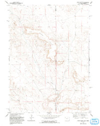
1974 Map of Spoon Butte
USGS Topo · Published 1978About this map
Spoon Butte dominates this high plains landscape at the border of Wyoming and Nebraska in the mid-1970s. The map illustrates a sparsely settled ranching or grazing territory where water resources are the primary landmarks. Intermittent drainages like Sheep Creek and George Draw cut through the terrain, punctuated by the essential infrastructure of rural livestock operations such as several Tank sites and a natural Spring. The survey meticulously records the state line dividing Goshen and Sioux counties, showing how political boundaries bisect this geographically continuous landform. The presence of numerous wells and water storage tanks suggests a landscape managed for cattle and agriculture, where the scarcity of permanent water sources dictated the patterns of human improvement and land use.
Find a feature on this map
7 named features on this map. Tap any name to fly to it.
Don’t see what you’re looking for? This feature index may not catch every label — zoom into the map to look around manually.
Map Details
Editions of this 1974 Spoon Butte Map
2 editions found
Other maps of this area

1896 · Patrick
USGS Topo · 1:125,000

1899 · Whistle Creek
USGS Topo · 1:125,000

1954 · Torrington
USGS Topo · 1:250,000

1955 · Alliance
USGS Topo · 1:250,000

1957 · Alliance
USGS Topo · 1:250,000

1958 · Torrington
USGS Topo · 1:250,000

1958 · Alliance
USGS Topo · 1:250,000

1963 · Chalk Buttes
USGS Topo · 1:24,000

1963 · Tea Kettle Rock
USGS Topo · 1:24,000
1963 · Carpenter Ranch
USGS Topo · 1:24,000