
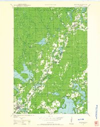
1980 Map of Spooner
USGS Topo · Published 1980About this map
The Lac Courte Oreilles Indian Reservation and the sprawling Chequamegon National Forest dominate the eastern reaches of this northwestern Wisconsin landscape. This era marks a significant transition in land use, as the former rail corridor of the Chicago and North Western begins its conversion into the Tuscobia-Park Falls State Trail. The map documents a water-rich environment where the Namekagon River and St Croix National Scenic Riverway snake through the northern forests, while established lakefront communities like Spooner, Shell Lake, and Rice Lake serve as regional anchors. Numerous conservation areas, such as the Weirgor Springs State Wildlife Area and Eddy Creek State Wildlife Area, illustrate the mid-century commitment to preserving the region's vast wetlands and watersheds, including the massive Dairyland Reservoir on the Flambeau River.
Find a feature on this map
70 named features on this map. Tap any name to fly to it.
Don’t see what you’re looking for? This feature index may not catch every label — zoom into the map to look around manually.
Map Details
Editions of this 1980 Spooner Map
This is the sole edition of this map. No revisions or reprints were ever made.
Other maps of this area

1942 · Clam Lake
USGS Topo · 1:48,000

1943 · Namekagon Lake
USGS Topo · 1:48,000

1944 · Exeland
USGS Topo · 1:48,000

1944 · Draper
USGS Topo · 1:48,000

1944 · Couderay
USGS Topo · 1:48,000

1944 · Radisson
USGS Topo · 1:48,000
1944 · Hayward
USGS Topo · 1:48,000

1945 · Namekagon Lake
USGS Topo · 1:48,000
1945 · Clam Lake
USGS Topo · 1:48,000

1945 · Meteor
USGS Topo · 1:48,000