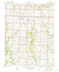
1942 Map of Sprague
USGS Topo · Published 1942About this map
Sprague serves as the primary settlement hub in this 1940s landscape, situated along a prominent highway corridor and an Old Railroad Grade. The map reveals a highly organized rural educational system, with family-named schools like Keith Sch, Montgomery Sch, and Sartorius Sch distributed across the townships of Newton, Howard, Osage, and Metz. This network of country schools highlights the density of the rural population before mid-century consolidation.
Find a feature on this map
25 named features on this map. Tap any name to fly to it.
Don’t see what you’re looking for? This feature index may not catch every label — zoom into the map to look around manually.
Map Details
Editions of this 1942 Sprague Map
3 editions found
Other maps of this area

1884 · Fort Scott
USGS Topo · 1:125,000

1886 · Nevada
USGS Topo · 1:125,000

1886 · Fort Scott
USGS Topo · 1:125,000

1887 · Butler
USGS Topo · 1:125,000

1887 · Mound City
USGS Topo · 1:125,000

1893 · Fort Scott
USGS Topo · 1:125,000

1893 · Mound City
USGS Topo · 1:125,000

1894 · Butler
USGS Topo · 1:125,000

1894 · Nevada
USGS Topo · 1:125,000

1936 · Rich Hill
USGS Topo · 1:24,000