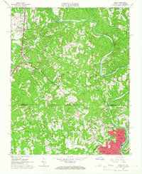
1964 Map of Spray
USGS Topo · Published 1966About this map
The Smith River meanders through this mid-1960s borderland survey, anchoring a landscape defined by the state line between Virginia and North Carolina. The industrial and residential centers of Leaksville and Spray dominate the southeastern corner, where the Southern Railway terminates. Further north in Henry County, the Norfolk and Western Railway cuts through Ridgeway, passing the Drewry Mason High Sch. The map reveals a dense network of rural community landmarks, including Matrimony Ch and St Pauls Ch, alongside numerous family and church cemeteries like Overlook Cem. This period shows the transition of the region's economy, with a high concentration of schools and churches scattered among the drainage basins of Matrimony Creek and Burgess Creek.
Find a feature on this map
52 named features on this map. Tap any name to fly to it.
Don’t see what you’re looking for? This feature index may not catch every label — zoom into the map to look around manually.
Map Details
Editions of this 1964 Spray Map
This is the sole edition of this map. No revisions or reprints were ever made.
Other maps of this area

1924 · Martinsville
USGS Topo · 1:48,000

1924 · Draper
USGS Topo · 1:48,000

1926 · Martinsville
USGS Topo · 1:62,500

1926 · Draper
USGS Topo · 1:62,500

1927 · Martinsville
USGS Topo · 1:62,500

1944 · Martinsville
USGS Topo · 1:62,500

1944 · Draper
USGS Topo · 1:62,500

1953 · Greensboro
USGS Topo · 1:250,000

1954 · Greensboro
USGS Topo · 1:250,000

1962 · Greensboro
USGS Topo · 1:250,000