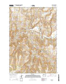
2014 Map of Spray
USGS Topo · Published 2014About this map
The John Day River carves a deep path through Wheeler County, defining the location of Spray, a riverside settlement at the junction of the John Day Hwy and the Heppner Spray Hwy. This 2014 survey reveals a landscape shaped by narrow canyons and high ridges, where the town sits tucked near Town Gulch and the Spray Cem. The surrounding terrain is marked by family and descriptive landmarks like Harper Mtn, Sentinel Peak, and Sourdough Ridge. Drainage patterns are clearly delineated by numerous named creeks including Parrish Cr and Kahler Cr, which feed into the main river valley. This map is essential for understanding the modern footprint of these remote canyonlands, showing the persistent relationship between the river corridor and the local transportation network that serves Haystack Valley and the various hollows to the south.
Find a feature on this map
30 named features on this map. Tap any name to fly to it.
Don’t see what you’re looking for? This feature index may not catch every label — zoom into the map to look around manually.
Map Details
Editions of this 2014 Spray Map
This is the sole edition of this map. No revisions or reprints were ever made.
Other maps of this area

1953 · Richmond
USGS Topo · 1:62,500

1953 · Kimberly
USGS Topo · 1:62,500

1953 · Picture
USGS Topo · 1:62,500

1953 · Spray
USGS Topo · 1:62,500

1955 · Canyon City
USGS Topo · 1:250,000

1959 · Canyon City
USGS Topo · 1:250,000

1980 · Monument
USGS Topo · 1:100,000
1990 · Whitetail Butte
USGS Topo · 1:24,000
1990 · Richmond
USGS Topo · 1:24,000
1990 · Johnson Heights
USGS Topo · 1:24,000