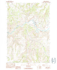
1990 Map of Spray
USGS Topo · Published 1990About this map
Spray sits at a strategic bend of the John Day River in Wheeler County, Oregon, where the canyon floor widens just enough to support a riverfront community. This 1990 survey captures the town's orientation along the water, flanked by significant landmarks like Sentinel Peak and the high elevations of Harper Mountain. The surrounding landscape is defined by a dense network of drainages, including Kahler Creek and Parrish Creek, which carve deep through the volcanic terrain. Evidence of local industry and infrastructure is visible at the Gravel Pit and along the winding routes of Highway 19 and Highway 207. The topographic detail highlights the transition from the river basin to the prominent Sourdough Ridge, providing a clear look at the land use and natural boundaries of this isolated river valley in the late twentieth century.
Find a feature on this map
26 named features on this map. Tap any name to fly to it.
Don’t see what you’re looking for? This feature index may not catch every label — zoom into the map to look around manually.
Map Details
Editions of this 1990 Spray Map
This is the sole edition of this map. No revisions or reprints were ever made.
Other maps of this area

1953 · Richmond
USGS Topo · 1:62,500

1953 · Kimberly
USGS Topo · 1:62,500

1953 · Picture
USGS Topo · 1:62,500

1953 · Spray
USGS Topo · 1:62,500

1955 · Canyon City
USGS Topo · 1:250,000

1959 · Canyon City
USGS Topo · 1:250,000

1980 · Monument
USGS Topo · 1:100,000
1990 · Whitetail Butte
USGS Topo · 1:24,000
1990 · Richmond
USGS Topo · 1:24,000
1990 · Johnson Heights
USGS Topo · 1:24,000