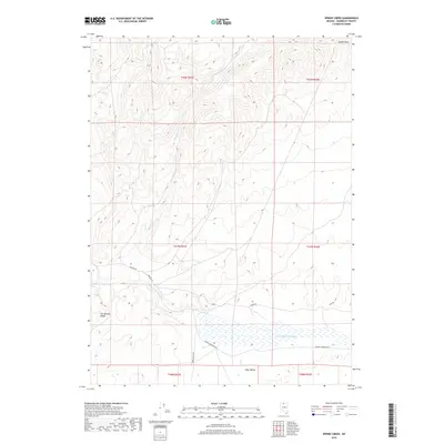
2018 Map of Spring Creek
USGS Topo · Published 2018About this map
Eden Valley occupies the southern portion of this high-desert landscape in Humboldt County, where the Little Humboldt River meanders through a series of wetland basins. The terrain rises sharply to the north toward the Ararat Hills, with drainage provided by the seasonal flows of Spring Cr and Eden Cr. This 2018 survey by the U.S. Geological Survey documents a sparse human footprint characterized primarily by a network of rural routes such as Shelton Rd and Chimney Reservoir Rd. The intersection of Eden Valley Rd and other local tracks suggests a remote ranching or grazing environment where water management and access remain central to the geography. The map clearly delineates township and range lines, including t41n r41e, providing a precise grid for land ownership and resource management in this corner of Nevada.
Find a feature on this map
16 named features on this map. Tap any name to fly to it.
Don’t see what you’re looking for? This feature index may not catch every label — zoom into the map to look around manually.
Map Details
Editions of this 2018 Spring Creek Map
This is the sole edition of this map. No revisions or reprints were ever made.
Other maps of this area

1882 · Paradise
USGS Topo · 1:250,000

1893 · Paradise
USGS Topo · 1:250,000

1945 · Hot Springs
USGS Topo · 1:62,500

1947 · Hot Springs Peak
USGS Topo · 1:62,500

1955 · McDermitt
USGS Topo · 1:250,000

1959 · McDermitt
USGS Topo · 1:250,000

1980 · Hardscrabble
USGS Topo · 1:24,000

1980 · Spring City
USGS Topo · 1:24,000
1980 · Chimney Reservoir
USGS Topo · 1:24,000
1980 · Whiskey Springs
USGS Topo · 1:24,000