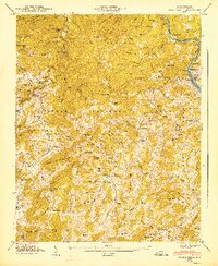
1947 Map of Spring Creek
USGS Topo · Published 1947About this map
Pisgah National Forest encompasses much of this Appalachian landscape, where steep ridges like Leadmine Mountain and Stony Spur Cliff define the drainage of the French Broad River. The Southern railroad follows the river's winding course along the eastern edge of the map, passing through the settlement of Barnard and near the Madison County seat of Marshall. This era of the late 1940s reveals a deeply settled mountain community dependent on small rural institutions, including the Upper Big Pine School and numerous family burying grounds such as Fortner Cem and Treadway Cem. Higher elevations are marked by the Duckett Lookout Tower on Rich Knob, providing a critical vantage point over the complex network of creeks like Big Pine Creek and Little Pine Creek that carve through the surrounding peaks.
Find a feature on this map
141 named features on this map. Tap any name to fly to it.
Don’t see what you’re looking for? This feature index may not catch every label — zoom into the map to look around manually.
Map Details
Editions of this 1947 Spring Creek Map
This is the sole edition of this map. No revisions or reprints were ever made.
Other maps of this area

1894 · Asheville
USGS Topo · 1:125,000

1901 · Asheville
USGS Topo · 1:125,000

1935 · Paint Rock
USGS Topo · 1:24,000

1935 · Hot Springs
USGS Topo · 1:24,000

1935 · Spring Creek
USGS Topo · 1:24,000

1935 · Lemon Gap
USGS Topo · 1:24,000

1936 · Marshall
USGS Topo · 1:24,000

1936 · Sandymush
USGS Topo · 1:24,000

1936 · White Rock
USGS Topo · 1:24,000

1936 · Hepco
USGS Topo · 1:24,000