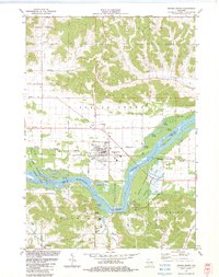
1983 Map of Spring Green
USGS Topo · Published 1983About this map
Spring Green serves as the central hub of this 1983 landscape, where the flat valley floor meets the complex driftless topography of the surrounding hills. The Wisconsin River dominates the southern half of the map, carving a wide path defined by numerous braided channels and islands including Long Island, Metcalf Island, and Sweet Island. This riparian corridor is preserved in part by the Lower Wisconsin State Wildlife Area, protecting the complex network of backwaters like Cynthia Slough and Jones Slough. South of the river, the landscape transitions into the hills of Wyoming, notably featuring the Taliesin estate and the Hillside Sch, reflecting the architectural legacy of the area. Educational and spiritual life is marked by sites like Unity Chapel and the Spring Green Chapel, while the local economy is evidenced by scattered resources like the Gravel Pit near Helena and a Ski Area on the southern slopes.
Find a feature on this map
59 named features on this map. Tap any name to fly to it.
Don’t see what you’re looking for? This feature index may not catch every label — zoom into the map to look around manually.
Map Details
Editions of this 1983 Spring Green Map
This is the sole edition of this map. No revisions or reprints were ever made.
Other maps of this area

1901 · Denzer
USGS Topo · 1:62,500

1905 · Richland Center
USGS Topo · 1:125,000

1920 · Blue Mounds
USGS Topo · 1:62,500

1922 · Blue Mounds
USGS Topo · 1:62,500

1957 · Madison
USGS Topo · 1:250,000

1958 · North Freedom
USGS Topo · 1:62,500

1958 · La Crosse
USGS Topo · 1:250,000

1960 · Madison
USGS Topo · 1:250,000

1960 · Plain
USGS Topo · 1:62,500

1960 · Spring Green
USGS Topo · 1:62,500