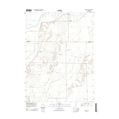
2015 Map of Spring Hill
USGS Topo · Published 2015About this map
The settlement of Spring Hill sits near the northern edge of this Illinois landscape, where the Rock River and Hadaway Slough define the riverine topography. The map illustrates a rural area divided between Whiteside and Henry counties, characterized by a grid of agricultural roads such as Town Hall Rd and N 3000th Ave. For those researching local history, the distribution of small burial grounds provides significant clues to early settlement patterns, including Sharon Cem, Loraine Cem, and Bowman Cem. The southern half of the quadrangle is marked by complex drainage networks like Big Slough Ditch and Blue Joint Ditch, which underscore the region's managed hydraulic history. Sharon Church and the isolated Pink Prairie Cem stand as distinct landmarks among the extensive farmland that dominates this Illinois river valley region.
Find a feature on this map
50 named features on this map. Tap any name to fly to it.
Don’t see what you’re looking for? This feature index may not catch every label — zoom into the map to look around manually.
Map Details
Editions of this 2015 Spring Hill Map
This is the sole edition of this map. No revisions or reprints were ever made.
Other maps of this area

1899 · Clinton
USGS Topo · 1:125,000

1929 · Annawan
USGS Topo · 1:62,500

1932 · Prophetstown
USGS Topo · 1:48,000

1932 · Annawan
USGS Topo · 1:62,500

1934 · Geneseo
USGS Topo · 1:62,500

1936 · Prophetstown
USGS Topo · 1:62,500

1952 · Erie
USGS Topo · 1:62,500
1953 · Geneseo
USGS Topo · 1:24,000
1953 · Atkinson
USGS Topo · 1:24,000

1958 · Davenport
USGS Topo · 1:250,000