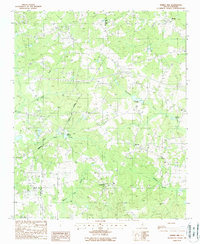
1988 Map of Spring Hill
USGS Topo · Published 1988About this map
Antioch and Pisgah anchor this rural landscape in the 1980s, where three county lines—Kershaw, Lee, and Sumter—converge in a complex boundary network. The topography is defined by the subtle drainage basins of Swift Creek and Little Swift Creek, which feed into localized industrial or agricultural water features like Shiver Millpond and Corbitts Millpond. Small clusters of settlements such as Red Hill and Spring Hill are scattered throughout the quadrangle, connected by a web of rural roads that suggest a persistent agricultural economy.
Find a feature on this map
18 named features on this map. Tap any name to fly to it.
Don’t see what you’re looking for? This feature index may not catch every label — zoom into the map to look around manually.
Map Details
Editions of this 1988 Spring Hill Map
This is the sole edition of this map. No revisions or reprints were ever made.
Other maps of this area

1935 · Camden
USGS Topo · 1:48,000

1938 · Camden
USGS Topo · 1:62,500

1938 · Hagood
USGS Topo · 1:62,500

1941 · Spartanburg
USGS Topo · 1:250,000

1942 · Camden
USGS Topo · 1:125,000

1953 · Camden South
USGS Topo · 1:24,000

1953 · Rembert
USGS Topo · 1:24,000

1953 · Spartanburg
USGS Topo · 1:250,000

1957 · Ashwood
USGS Topo · 1:62,500

1960 · Spartanburg
USGS Topo · 1:250,000