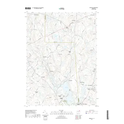
2018 Map of Spring Hill
USGS Topo · Published 2018About this map
Mansfield Hollow Lake and its surrounding flood control lands dominate the southern portion of this region, where the Mount Hope River and Fenton River converge. The landscape is dotted with historical crossroad settlements and family-named cemeteries, reflecting the agrarian and early industrial character of eastern Connecticut. Small villages like Atwoodville, Gurleyville, and Mansfield Center are situated along the river valleys, historically tethered to water power and early mill sites. The eastern section around Chaplin and Bedlam Corner shows a typical New England pattern of upland farms and valley dwellings. Topographically, the area is defined by numerous glacial drumlins and ridges such as Pumpkin Hill and Wormwood Hill. A significant concentration of burial grounds, including Babcock Cem and South Ashford Cem, provides a detailed record of the early families who settled this corner of the Windham and Tolland county line.
Find a feature on this map
172 named features on this map. Tap any name to fly to it.
Don’t see what you’re looking for? This feature index may not catch every label — zoom into the map to look around manually.
Map Details
Editions of this 2018 Spring Hill Map
This is the sole edition of this map. No revisions or reprints were ever made.
Other maps of this area

1892 · Woodstock
USGS Topo · 1:62,500

1892 · Tolland
USGS Topo · 1:62,500

1892 · Norwich
USGS Topo · 1:62,500

1892 · Gilead
USGS Topo · 1:62,500

1921 · Tolland
USGS Topo · 1:62,500

1921 · Woodstock
USGS Topo · 1:62,500

1944 · South Coventry
USGS Topo · 1:31,680
1944 · Hampton
USGS Topo · 1:31,680

1944 · Columbia
USGS Topo · 1:31,680
1945 · Spring Hill
USGS Topo · 1:31,680