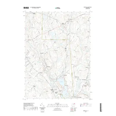
2021 Map of Spring Hill
USGS Topo · Published 2021About this map
The Fenton River and Mount Hope River converge toward the Mansfield Hollow Lake reservoir, defining a landscape of eastern Connecticut hills and valleys. This 2021 update shows the modern footprint of the University of Connecticut campus on the western edge, while preserving the spatial data of early settlement nodes like Mansfield Center and Mansfield Hollow. Genealogy researchers will find numerous burial grounds including the Olde Mansfield Center Cem, Snow Cem, and the Saint Philip Cem near Warrenville. Small hamlets like Gurleyville, Chaffeeville, and Atwoodville follow the river corridors, illustrating how the region's topography dictated its historical development. The map also documents the extensive wetland areas such as Cedar Swamp and Wild Life Marsh Reservoir, which sit alongside distinctive elevations like Wormwood Hill and Pumpkin Hill.
Find a feature on this map
185 named features on this map. Tap any name to fly to it.
Don’t see what you’re looking for? This feature index may not catch every label — zoom into the map to look around manually.
Map Details
Editions of this 2021 Spring Hill Map
This is the sole edition of this map. No revisions or reprints were ever made.
Other maps of this area

1892 · Woodstock
USGS Topo · 1:62,500

1892 · Tolland
USGS Topo · 1:62,500

1892 · Norwich
USGS Topo · 1:62,500

1892 · Gilead
USGS Topo · 1:62,500

1921 · Tolland
USGS Topo · 1:62,500

1921 · Woodstock
USGS Topo · 1:62,500

1944 · South Coventry
USGS Topo · 1:31,680
1944 · Hampton
USGS Topo · 1:31,680

1944 · Columbia
USGS Topo · 1:31,680
1945 · Spring Hill
USGS Topo · 1:31,680