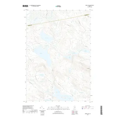
2018 Map of Spring Lake
USGS Topo · Published 2018About this map
The Passadumkeag River winds through this heavily wooded landscape in eastern Maine, establishing a complex network of waterways at the border of Penobscot and Hancock counties. This environment is defined by an extensive series of interconnected basins including Lower Pistol Lake, Middle Pistol Lake, and Upper Pistol Lake, which feed into Pistol Stream. To the south, the massive expanse of Nicatous Lake reaches into Porter Cove, while the heights of Duck Mtn provide a significant topographical landmark overlooking Duck Lake Brook. The map reveals a modern network of timber and access roads, such as Nicatous Stream Rd and Passadumkeag AWT, which navigate the wetlands around Porter Pond and Spring Lake, reflecting the region's enduring character as a working forest and watershed.
Find a feature on this map
33 named features on this map. Tap any name to fly to it.
Don’t see what you’re looking for? This feature index may not catch every label — zoom into the map to look around manually.
Map Details
Editions of this 2018 Spring Lake Map
This is the sole edition of this map. No revisions or reprints were ever made.
Other maps of this area

1920 · Winn
USGS Topo · 1:62,500

1931 · Springfield
USGS Topo · 1:48,000

1931 · Saponac
USGS Topo · 1:48,000

1932 · Nicatous Lake
USGS Topo · 1:48,000

1934 · Saponac
USGS Topo · 1:62,500

1934 · Nicatous Lake
USGS Topo · 1:62,500

1934 · Springfield
USGS Topo · 1:62,500

1954 · Millinocket
USGS Topo · 1:250,000

1957 · Saponac
USGS Topo · 1:62,500

1958 · Millinocket
USGS Topo · 1:250,000