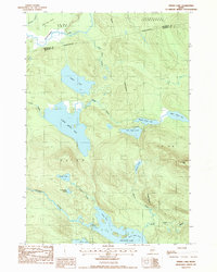
1987 Map of Spring Lake
USGS Topo · Published 1988About this map
The Passadumkeag River flows across the northern reaches of this landscape, marking a boundary between Lakeville Plantation and the unorganized territories of eastern Maine. This 1980s survey captures a vast wetland and water-dominant environment, punctuated by the distinctive 1000 Acre Heath and the interconnected waters of the Pistol Lake chain. The topography reveals a network of glacial lakes and streams, including Spring Lake and the various branches of Lower Pistol Lake, Middle Pistol Lake and Upper Pistol Lake. To the south, the terrain rises toward Duck Mtn, overlooking Nicatous Lake and its northern inlets. The map provides clear evidence of the complex drainage patterns of the region, from the winding Nicatous Stream to the isolated waters of Trueworthy Pond and Porter Pond.
Find a feature on this map
26 named features on this map. Tap any name to fly to it.
Don’t see what you’re looking for? This feature index may not catch every label — zoom into the map to look around manually.
Map Details
Editions of this 1987 Spring Lake Map
This is the sole edition of this map. No revisions or reprints were ever made.
Other maps of this area

1920 · Winn
USGS Topo · 1:62,500

1931 · Springfield
USGS Topo · 1:48,000

1931 · Saponac
USGS Topo · 1:48,000

1932 · Nicatous Lake
USGS Topo · 1:48,000

1934 · Saponac
USGS Topo · 1:62,500

1934 · Nicatous Lake
USGS Topo · 1:62,500

1934 · Springfield
USGS Topo · 1:62,500

1954 · Millinocket
USGS Topo · 1:250,000

1957 · Saponac
USGS Topo · 1:62,500

1958 · Millinocket
USGS Topo · 1:250,000