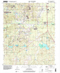
1994 Map of Spring Lake
USGS Topo · Published 2000About this map
The Saline and Pulaski County border area is defined by a dense network of suburban development and rural homesteads during the mid-1990s. This survey records the transition between established communities like East End and Landmark and the smaller settlements of Maple and Bingham. The landscape is notably dotted with numerous places of worship, such as Ironton Chapel, Faith Chapel Ch, and the East End Church, reflecting the area's social fabric. Educational centers like the Landmark Sch and East End School are clearly marked, alongside specialized landmarks including the Carmelite Novitiate near Mary Lake. Water plays a central role in the local geography, with Spring Lake, Ferguson Lake, and Lakeside providing focal points for the surrounding terrain. Notable family-named thoroughfares such as Kling Road, Singley Road, and Atwood Road weave through the hills, providing access to historic burial sites like Upchurch Cem and Hicks Cem.
Find a feature on this map
62 named features on this map. Tap any name to fly to it.
Don’t see what you’re looking for? This feature index may not catch every label — zoom into the map to look around manually.
Map Details
Editions of this 1994 Spring Lake Map
This is the sole edition of this map. No revisions or reprints were ever made.
Other maps of this area

1891 · Little Rock
USGS Topo · 1:125,000

1893 · Little Rock
USGS Topo · 1:125,000

1932 · Pastoria
USGS Topo · 1:62,500

1935 · Little Rock
USGS Topo · 1:24,000

1935 · Sweet Home
USGS Topo · 1:24,000

1935 · Alexander
USGS Topo · 1:48,000

1935 · Pastoria
USGS Topo · 1:62,500

1940 · Woodson
USGS Topo · 1:31,680

1941 · Alexander
USGS Topo · 1:62,500

1944 · Alexander
USGS Topo · 1:31,680