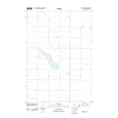
2012 Map of Spring Lake
USGS Topo · Published 2012About this map
Spring Lake anchors this glacial landscape in Walworth County, stretching across the center of a quadrangle dominated by the section-line grid of the American West. The small settlement of Alamo sits to the northeast, positioned along 319th Ave near the upper reaches of Swan Lake Cr. This 2012 survey by the U.S. Geological Survey illustrates the intersection of modern road infrastructure with the natural hydrology of the Great Plains, where numerous unnamed prairie potholes and depressions dot the fields around the primary drainage of the creek. The strictly rectangular road network, composed of numbered routes like 135th St and 317th Ave, reflects the enduring legacy of the Public Land Survey System as it organizes the rural South Dakota economy.
Find a feature on this map
17 named features on this map. Tap any name to fly to it.
Don’t see what you’re looking for? This feature index may not catch every label — zoom into the map to look around manually.
Map Details
Editions of this 2012 Spring Lake Map
This is the sole edition of this map. No revisions or reprints were ever made.
Other maps of this area

1954 · Aberdeen
USGS Topo · 1:250,000

1956 · Aberdeen
USGS Topo · 1:250,000

1974 · Lowry
USGS Topo · 1:24,000

1974 · Hoven Muni. Airport
USGS Topo · 1:24,000

1974 · Spring Lake
USGS Topo · 1:24,000
1974 · Lowry NW
USGS Topo · 1:24,000

1974 · Bowdle
USGS Topo · 1:24,000

1978 · Bowdle SW
USGS Topo · 1:24,000

1978 · Bowdle-Hosmer Lake
USGS Topo · 1:24,000

1978 · Java SE
USGS Topo · 1:24,000