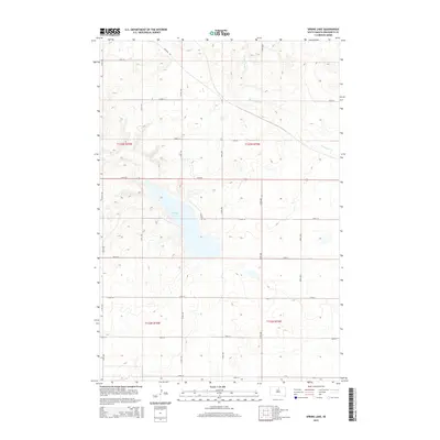
2015 Map of Spring Lake
USGS Topo · Published 2015About this map
Spring Lake and its surrounding prairie landscape define this portion of Walworth County, where the topography is shaped by glacial depressions and subtle drainage patterns. The hydrology is anchored by Swan Lake Cr, which winds through the northern sections of the township. This 2015 survey reveals a strictly organized section-line road network, where routes like 317th Ave and 134th St segment the agricultural land. Most notable is the persistence of diagonal travel through the grid, exemplified by the path of Angling Rd in the north. This map reflects the enduring rural character of the Great Plains, where the geometry of the Public Land Survey System meets the natural contours of the South Dakota landscape.
Find a feature on this map
23 named features on this map. Tap any name to fly to it.
Don’t see what you’re looking for? This feature index may not catch every label — zoom into the map to look around manually.
Map Details
Editions of this 2015 Spring Lake Map
This is the sole edition of this map. No revisions or reprints were ever made.
Other maps of this area

1954 · Aberdeen
USGS Topo · 1:250,000

1956 · Aberdeen
USGS Topo · 1:250,000

1974 · Lowry
USGS Topo · 1:24,000

1974 · Hoven Muni. Airport
USGS Topo · 1:24,000

1974 · Spring Lake
USGS Topo · 1:24,000
1974 · Lowry NW
USGS Topo · 1:24,000

1974 · Bowdle
USGS Topo · 1:24,000

1978 · Bowdle SW
USGS Topo · 1:24,000

1978 · Bowdle-Hosmer Lake
USGS Topo · 1:24,000

1978 · Java SE
USGS Topo · 1:24,000