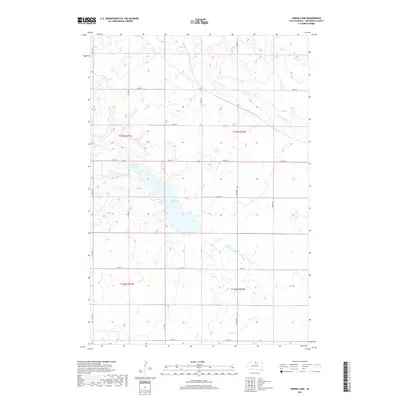
2017 Map of Spring Lake
USGS Topo · Published 2017About this map
Swan Lake Cr meanders through the central and northern reaches of this Walworth County landscape, defining the local hydrology within the Public Land Survey System grids of Townships 122 and 123 North. The terrain is characterized by a high concentration of prairie potholes and seasonal wetlands, illustrating the glaciated topography of the Missouri Coteau region. While the map is sparse in named settlements, the dense network of rural routes such as 134th St and 319th Ave provides a clear view of the agricultural section-line road system. Researchers can examine the precise layout of local drainages and the expansive wetland complexes that have shaped land use and field patterns in this part of South Dakota.
Find a feature on this map
1 named feature on this map. Tap any name to fly to it.
Don’t see what you’re looking for? This feature index may not catch every label — zoom into the map to look around manually.
Map Details
Editions of this 2017 Spring Lake Map
This is the sole edition of this map. No revisions or reprints were ever made.
Other maps of this area

1954 · Aberdeen
USGS Topo · 1:250,000

1956 · Aberdeen
USGS Topo · 1:250,000

1974 · Lowry
USGS Topo · 1:24,000

1974 · Hoven Muni. Airport
USGS Topo · 1:24,000

1974 · Spring Lake
USGS Topo · 1:24,000
1974 · Lowry NW
USGS Topo · 1:24,000

1974 · Bowdle
USGS Topo · 1:24,000

1978 · Bowdle SW
USGS Topo · 1:24,000

1978 · Bowdle-Hosmer Lake
USGS Topo · 1:24,000

1978 · Java SE
USGS Topo · 1:24,000