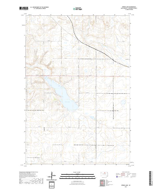
2021 Map of Spring Lake
USGS Topo · Published 2021About this map
Spring Lake and its surrounding wetlands define this prairie landscape in Walworth County. The terrain is a network of intermittent water bodies and depressions typical of the Missouri Coteau region, where drainage is primarily internal or through small watercourses like Swan Lake Cr. The map reveals a strictly regulated section-line road grid, including north-south corridors like 315th Ave and 319th Ave, and east-west routes such as 134th St and 137th St. These roads mark the boundaries of agricultural plots within townships T123N and T122N, illustrating the persistent influence of the Public Land Survey System on the modern South Dakota countryside.
Find a feature on this map
17 named features on this map. Tap any name to fly to it.
Don’t see what you’re looking for? This feature index may not catch every label — zoom into the map to look around manually.
Map Details
Editions of this 2021 Spring Lake Map
This is the sole edition of this map. No revisions or reprints were ever made.
Other maps of this area

1954 · Aberdeen
USGS Topo · 1:250,000

1956 · Aberdeen
USGS Topo · 1:250,000

1974 · Lowry
USGS Topo · 1:24,000

1974 · Hoven Muni. Airport
USGS Topo · 1:24,000

1974 · Spring Lake
USGS Topo · 1:24,000
1974 · Lowry NW
USGS Topo · 1:24,000

1974 · Bowdle
USGS Topo · 1:24,000

1978 · Bowdle SW
USGS Topo · 1:24,000

1978 · Bowdle-Hosmer Lake
USGS Topo · 1:24,000

1978 · Java SE
USGS Topo · 1:24,000