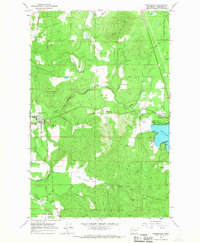
1965 Map of Springdale
USGS Topo · Published 1967About this map
The Great Northern railway forms the backbone of transportation in this corner of Stevens County, winding through the valley past the settlement of Springdale. By the mid-1960s, the area shows a landscape defined by both recreational and industrial use, with a prominent Boat Ramp and Silver Point on the shores of Loon Lake contrasted against the heavy resource extraction visible at Limekiln Hill, which features a Quarry and multiple borrow pits.
Find a feature on this map
25 named features on this map. Tap any name to fly to it.
Don’t see what you’re looking for? This feature index may not catch every label — zoom into the map to look around manually.
Map Details
Editions of this 1965 Springdale Map
3 editions found
Other maps of this area

1927 · Chewelah
USGS Topo · 1:125,000

1930 · Chewelah
USGS Topo · 1:125,000

1944 · Clayton
USGS Topo · 1:62,500

1944 · Wellpinit
USGS Topo · 1:62,500

1950 · Clayton
USGS Topo · 1:62,500

1953 · Wellpinit
USGS Topo · 1:62,500

1955 · Spokane
USGS Topo · 1:250,000

1958 · Spokane
USGS Topo · 1:250,000

1958 · Sandpoint
USGS Topo · 1:250,000

1963 · Sandpoint
USGS Topo · 1:250,000