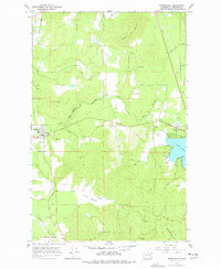
1965 Map of Springdale
USGS Topo · Published 1977About this map
The Great Northern railway line serves as a central spine for this 1960s portrait of southern Stevens County, where the settlement of Springdale anchors a landscape of timbered slopes and creek bottoms. The rail corridor follows the winding path of Sheep Creek toward the southern boundary of the quadrangle, passing beneath the prominent heights of Jumpoff Joe Mountain and Limekiln Hill, the latter of which shows evidence of historical industry at a Quarry.
Find a feature on this map
28 named features on this map. Tap any name to fly to it.
Don’t see what you’re looking for? This feature index may not catch every label — zoom into the map to look around manually.
Map Details
Editions of this 1965 Springdale Map
3 editions found
Other maps of this area

1927 · Chewelah
USGS Topo · 1:125,000

1930 · Chewelah
USGS Topo · 1:125,000

1944 · Clayton
USGS Topo · 1:62,500

1944 · Wellpinit
USGS Topo · 1:62,500

1950 · Clayton
USGS Topo · 1:62,500

1953 · Wellpinit
USGS Topo · 1:62,500

1955 · Spokane
USGS Topo · 1:250,000

1958 · Spokane
USGS Topo · 1:250,000

1958 · Sandpoint
USGS Topo · 1:250,000

1963 · Sandpoint
USGS Topo · 1:250,000